

Modern Technology Must Be Used for Accurate Land Surveys

Date:

Comments:

Modern Technology Must Be Used for Accurate Land Surveys.

Marking the 37th National Land Survey Day, Deputy Commissioner S.J. Somashekar emphasised the need for accurate land surveys using modern technologies such as GPS, drones, and remote sensing.
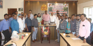
He urged officials to prioritise pending Podi survey works and complete them within stipulated timelines.

Officials highlighted that over 3.78 lakh land records have been digitised in Kodagu.

The evolution of land surveys-from traditional chain methods to advanced digital mapping-was also discussed.

Join our WhatsApp Group for News and Article Alerts

CLN Policy on Comments:

CLN reserves the right to edit or not publish any comment, especially if it contains offensive or inappropriate language.

LEAVE A REPLY

Please enter your comment!
Please enter your name here

The maximum upload file size: 100 MB. You can upload: image, audio, video, document, spreadsheet, interactive, text, archive, code, other. Links to YouTube, Facebook, Twitter and other services inserted in the comment text will be automatically embedded. Drop files here

Recent Comments

Subscribe to CLN Print Edition

spot_img

More Posts
Related

Kangaroo Care Hospital Distributes Reflective Jackets to Traffic Police

Kangaroo Care Hospital, Mysuru, organised a social service programme...

Karnataka Grameena Bank Staff Conduct Cleanliness Drive in Madikeri

A special cleanliness drive was organised on Thursday on...

Site Inspected for New Court Building in Virajpet

MLA and Chief Minister's Political Secretary A.S. Ponnanna, along...

Arebhashe Gowda Community has Distinctive Cultural Heritage: MLA Ponnanna

Karnataka Chief Minister's Political Secretary and Virajpet MLA Ajjikuttira...